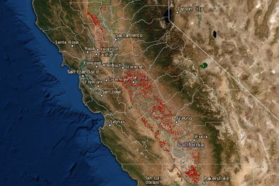
Understanding the impacts and opportunities of almond production is fundamental to responsible resource management, regulatory compliance and planning for the sustainable future of California agriculture. The maps, developed in partnership with Land IQ, a Sacramento-based agricultural and environmental scientific research and consulting firm, constitute a comprehensive, living map of California almonds that draws upon multiple sources of information and extensive validation to create a highly accurate, orchard-by-orchard view of the industry.

Land IQ Acreage Reports
- 2024 Standing Acreage and 2024 Removed Acreage - Final Estimate
- 2024 Standing Acreage - Initial Estimate
- 2023 Standing Acreage and 2023 Removed Acreage - Final Estimate
- 2023 Standing Acreage - Initial Estimate
- 2022 Standing Acreage and 2022 Removed Acreage - Final Estimate
- 2022 Standing Acreage and 2022 Removed Acreage – Initial Estimate
- 2021 Standing Acreage and 2021 Removed Acreage – Final Estimate
- 2021 Standing Acreage and 2021 Removed Acreage – Initial Estimate
- 2020 Standing Acreage – Final Estimate
- 2020 Removed Acreage – Initial Estimate
- 2020 Standing Acreage – Initial Estimate – Bearing Only
- 2019 Standing Acreage - Final Estimate
- 2018 Standing Acreage - Final Estimate
- 2016 Standing Acreage - Final Estimate
- 2014 Standing Acreage - Final Estimate
- 2012 Standing Acreage - Final Estimate
- 2010 Standing Acreage - Final Estimate
Behind the maps is a robust data set.
Beginning in 2019, the Almond Board adjusted the mapping process to include annual reporting that now involves the release of two acreage summaries: an initial estimate that includes a bearing acreage estimate and a final estimate that includes bearing and non-bearing acreage estimates for the same production year. The final estimate, which builds off the initial estimate provided earlier in the year, utilizes a combination of extensive ground truthing and advanced remote sensing analytics to refine Land IQ’s initial findings. The ground truthing effort maps a subset of the almond orchard population throughout the Central Valley as well as all other crops along a nearly 4,000-mile route. Land IQ then uses this data to calibrate algorithms in a remotely sensed image analysis process. This process differentiates almond orchards from other tree and annual crops.
To date, findings from Land IQ have allowed the almond industry to drive innovation, further scientific research and educate stakeholders about almond-related opportunities. For example, through the mapping project, analysis of almond acreage indicates that 60 percent of almond orchards grow on soil moderately good or better for groundwater recharge, an important initiative the almond community is tackling to increase overall water availability for farmers and all of California.
Findings from the spatial map are being used by USDA National Agricultural Statistics Service (NASS) to fine-tune the official almond acreage reports and other forecasts and reports, and serve as a complementary almond industry resource.1 The USDA-NASS crop and acreage reports are the official USDA estimates and will continue to be the official statistics for the almond industry.
Current mapping data.
Crop Acreage
Based on the mapping assessment of California almond orchards, Land IQ found that in 2020 there were 1,552,754 total standing acres of almonds: 1,242,203 bearing acres and 310,551 non-bearing acres (non-bearing defined as orchards planted in 2018, 2019, and 2020).2
Individuals referencing the 2020 map layer on the Land IQ web map should note that the layer accounts only for bearing acreage. However, some non-bearing orchards that were visually confirmed from ground truthing may also appear on the map, and the numerical Land IQ almond acreage estimates above account for these orchards.3
Groundwater Recharge
A piece of the Almond Board’s larger research program is investigating using almond orchards to recharge California’s groundwater. Land IQ 2014 almond mapping indicates that nearly 675,000 acres of almond orchards grow on soil that is moderately good or better for groundwater recharge. This includes: 4,119 acres of almonds which are categorized as ‘very good’ in their groundwater recharge potential; 271,509 acres as ‘good’; and 396,790 acres as ‘moderately good.4
Need assistance?
If you need help accessing or navigating the maps, please contact Land IQ’s support staff at technical.support@landiq.com or (916) 265-6330.
1 Land IQ draws on multiple lines of evidence including agronomic and remote sensing knowledge, unique field boundaries, robust on-the-ground verification, publicly available imagery and other spatial and non-spatial resources. USDA-NASS relies on grower surveys, nursery surveys, the USDA Census of Agriculture, California county agricultural commissioner reports, monthly industry position reports and extrapolation based on the summation of available knowledge of the industry.
2 Land IQ. California Statewide Almond Mapping - 2020. Based on data from USDA National Agricultural Imagery Program (NAIP) and USGS Landsat.
3 The estimated non-bearing acreages for 2019 and 2020 are numeric estimates only, however based on extensive ground truthing, image analysis, and other lines of evidence. While bearing acreage mapping has been validated with an accuracy of 98.8%, non-bearing numerical acreage estimates should be understood to have an estimated +/-10% potential variability.
4 Land IQ. Groundwater Recharge Suitability Layer. Nov. 2015. Based on data from UC Davis Soil Agricultural Groundwater Banking Index, California DWR Groundwater Levels, USGS Central Valley Hydrologic Model Well Logs, USGS Corcoran Clay Extent, DWR Irrigation District Coverage, USGS Hydrology and Points of Diversion.
